- Home
- Science
- Science News
- GPS, Satellite Data Can Help Reduce Post Earthquake Deaths: Study
GPS, Satellite Data Can Help Reduce Post-Earthquake Deaths: Study

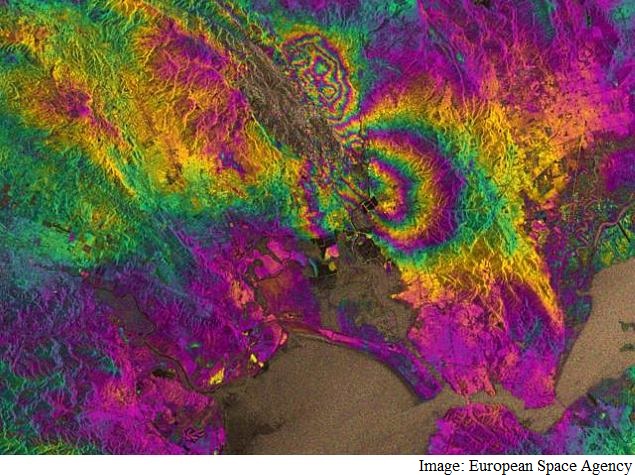
For the study, assistant professor William Barnhart from University of Iowa used GPS and satellite measurements from the magnitude 6.0 earthquake in South Napa, California on August 24, 2014.
He created a 3D map of how the ground surface moved in response to the earthquake.
The map was made without using traditional rapid response instruments such as seismometers which may not afford the same level of detail for similar events around the globe.
"By having the 3D knowledge of the earthquake itself, we can make predictions of the ground shaking, without instruments to record that ground shaking, and then can make estimates of what the human and infrastructure impacts will be - in terms of both fatalities and dollars," said Barnhart who used data from the United States Geological Survey (USGS).
The study, that appeared in the journal Seismological Research Letters, shows that that GPS and satellite readings can be used as a tool to shorten earthquake response times.
The technique will be most useful in the developing world.
"The catastrophic magnitude 7.0 earthquake that hit Haiti in 2010 and killed nearly 316,000 people is the perfect example for the usefulness of this kind of tool," Barnhart said.
On an international scale, it dramatically reduces the time between when an earthquake happens, when buildings start to fall down, and when aid starts to show up, the authors wrote.
For the study, they first used GPS and satellite readings to measure the very small-millimetre-to-centimetre-sized-displacements of the ground's surface that were caused by the earthquake.
They fed those measurements into a mathematical equation that inverts the data and relates how much the ground moved to the degree of slip on the fault plane.
Slip describes the amount, timing, and distribution of fault plane movement during an earthquake.
This allowed the group to determine the location, orientation, and dimensions of the entire fault without setting foot on the ground near the earthquake.
The resulting model is a 3D map of fault slip beneath the Earth's surface.
The entire procedure takes only a few minutes to complete.
The information contained in Barnhart's study could be used to create further tools for predicting the economic and human tolls of earthquakes.
For the latest tech news and reviews, follow Gadgets 360 on X, Facebook, WhatsApp, Threads and Google News. For the latest videos on gadgets and tech, subscribe to our YouTube channel. If you want to know everything about top influencers, follow our in-house Who'sThat360 on Instagram and YouTube.
Related Stories
- Galaxy S24 Series
- MWC 2024
- Apple Vision Pro
- Oneplus 12
- iPhone 14
- Apple iPhone 15
- OnePlus Nord CE 3 Lite 5G
- iPhone 13
- Xiaomi 14 Pro
- Oppo Find N3
- Tecno Spark Go (2023)
- Realme V30
- Best Phones Under 25000
- Samsung Galaxy S24 Series
- Cryptocurrency
- iQoo 12
- Samsung Galaxy S24 Ultra
- Giottus
- Samsung Galaxy Z Flip 5
- Apple 'Scary Fast'
- Housefull 5
- GoPro Hero 12 Black Review
- Invincible Season 2
- JioGlass
- HD Ready TV
- Laptop Under 50000
- Smartwatch Under 10000
- Latest Mobile Phones
- Compare Phones
- Motorola Edge 50 Fusion
- Oppo A1i
- Oppo A1s
- Motorola Edge 50 Ultra
- Leica Leitz Phone 3
- Moto G64 5G
- Moto G04s
- iQOO Z9 Turbo
- Asus ZenBook Duo 2024 (UX8406)
- Dell Inspiron 14 Plus
- Realme Pad 2 Wi-Fi
- Redmi Pad Pro
- Cult Shock X
- Fire-Boltt Oracle
- LG 65-inch 4K Ultra HD Smart LED TV 65UR7500PSC
- Xiaomi 32 Inch LED HD Ready Smart TV (L32M6-RA-L32M7-RA)
- Sony PlayStation 5 Slim Digital Edition
- Sony PlayStation 5 Slim
- Onida 1.5 Ton 3 Star Inverter Split AC (IR183TSN)
- Haier 1.5 Ton 3 Star Window AC (HWU18TF-EW3BE-FS)


